
Skeda:Satellite image of Guinea-Bissau in January 2003.jpg

Madhësia e këtij shikimi: 800 × 490 pixel. Rezolucione të tjera: 320 × 196 pixel | 640 × 392 pixel | 1.024 × 627 pixel | 1.361 × 833 pixel.
Dokument origjinal (1.361 × 833 pixela, madhësia e skedës: 169 KB, tipi MIME: image/jpeg)
Përmbledhje
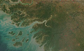
| Përshkrimi | Satellite image of Guinea-Bissau in January 2003. |
| Data | |
| Burimi | Cropped from original: http://visibleearth.nasa.gov/view_rec.php?id=4841 |
| Autori | Jacques Descloitres, MODIS Rapid Response Team, NASA/GSFC |
The Islands are known as Bijagos Archipelago, in English, Bissagos in portuguese, one of them, nearest to the coast towards the centre of the image, furthest to the East being Bolama
Licencim
| This file is in the public domain in the United States because it was solely created by NASA. NASA copyright policy states that "NASA material is not protected by copyright unless noted". (See Template:PD-USGov, NASA copyright policy page or JPL Image Use Policy.) | ||
 |
Warnings:
|
Historiku i dosjes
Shtypni një datë/kohë për ta parë skedën ashtu si dukej në atë kohë.
| Data/Ora | Miniaturë | Përmasa | Përdoruesi | Koment | |
|---|---|---|---|---|---|
| e tanishme | 22 dhjetor 2004 13:47 | | 1.361 × 833 (169 KB) | Hautala | {{PD-USGov-NASA}} Satellite image of Guinea-Bissau in January 2003. Cropped image, original taken from NASA's Visible Earth http://visibleearth.nasa.gov/cgi-bin/viewrecord?23921 |
Përdorimi i skedës
faqe lidhet tek kjo skedë:
Përdorimi global i skedës
Kjo skedë përdoret nga Wiki të tjera në vijim:
- Përdorimi në af.wikipedia.org
- Përdorimi në ar.wikipedia.org
- Përdorimi në azb.wikipedia.org
- Përdorimi në ca.wikipedia.org
- Përdorimi në de.wikipedia.org
- Përdorimi në en.wikipedia.org
- Përdorimi në es.wikipedia.org
- Përdorimi në fa.wikipedia.org
- Përdorimi në fr.wikipedia.org
- Përdorimi në fy.wikipedia.org
- Përdorimi në hif.wikipedia.org
- Përdorimi në hu.wiktionary.org
- Përdorimi në it.wikipedia.org
- Përdorimi në nl.wikipedia.org
- Përdorimi në or.wikipedia.org
- Përdorimi në pt.wikipedia.org
- Përdorimi në ru.wikipedia.org
- Përdorimi në simple.wikipedia.org
- Përdorimi në uk.wikipedia.org
- Përdorimi në yi.wikipedia.org